Our Oceanside Water
  • Home
  • Facts/Stats
    • Local Tide Guide
    • Terminology
    • History of Our Water Use
    • Water Quantity
    • Water Quality >
      • Existing contamination risks
    • Water Source Protection
    • Water Testing
    • Education
    • Private Wells
  • Our Community's Water
    • Upland storage a better option
    • City Of Parksville
    • Town Of Qualicum Beach >
      • Qualicum Waterfront
    • RDN Electoral Areas F, G, H
    • Englishman River Water Service >
      • New Water Treatment Plant Aquifer Storage
      • Water Treatment Questions
      • Arrowsmith Lake
      • Other Water Supply Options
      • The Clay Banks
    • Other Private Utilities
  • Environmental Topics
    • Our Land
    • Estuaries
    • Watersheds/ Rivers and Creeks/ Lakes / Wetlands >
      • Englishman River System
    • Our Climate
    • Groundwater
    • Groundwater Levels
    • Hydrology
  • Water Related Subjects and Links
    • Englishman River Estuary
  • Water Management/Governance
  • Groundwater Licencing
  • Opinion Blog
  • ContactMe
  • About the Authors
    • NAVIGATION
  • Hydrologic Impact Zone
  • Evapotranspiration Potential
  • 26,000 Days
  • Home Draft
  • Urban Water Waste

An Independent Water Website

The purpose of this website is to provide information, resource material, links and an opportunity for input.

NAVIGATION
 Welcome to our Independent  ​Arrowsmith-Oceanside Water Website
The area of interest for this website is the area north-east of Mount Arrowsmith including the communities of Nanoose, Parksville, French Creek, Qualicum Beach, Dashwood, Errington, Coombs and Hilliers. The Arrowsmith - Oceanside area has a population of about 35 thousand people. Within this general area there are about 45 regional, municipal and private water systems, and several thousand private wells.
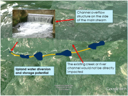
 High Elevation Water Storage
Has Big Potential
Picture
To see a graphic concept for providing high quality water at low cost. Please click the drip
Picture

Picture
Qualicum Beach Waterfront
                                   Click the drip to link to                                              some independent ideas


​Are the Sources of Potential Drinking Water Contamination Risks Being Withheld from Consumers?
​You Decide
​

Picture
To see an overview of this shocking situation                                  Please Click the Drip
​


​In April 2013 - The Town of Qualicum Beach embarked on a Waterfront Master Plan project. The planning process was to consider the effects of sea level rise and storm damage from the effects of climate change.
After about 40 months of studies, meetings, public input and thousands of pages of documents, there appears to be very little in the plan to address the sea defence issue.
A pier structure or wooden walkway located at the exposed waterfront would be subject to wave damage and the extreme pounding of large floating logs and trees than routinely move around during storms. Also a raised pier would not help to prevent shoreline storm damage.
From observations of exposed piers and boardwalks around the world they are typically elevated several meters above potential wave crests. On the Qualicum waterfront a raised pier would critically impact the view-scape.
This causeway concept I offer would help to protect shoreline beaches, park and walkway and withstand the storm and high water impacts.
Picture
Water News and Views

KEEPING UP TO DATE

Picture
​
------------------------------------------------------------------------------
Where do we Stand in the Englishman River Estuary
Picture
The floodplains and estuary lands are vulnerable to flooding and storm damage             
Please click the drip to link to a short graphic presentation.
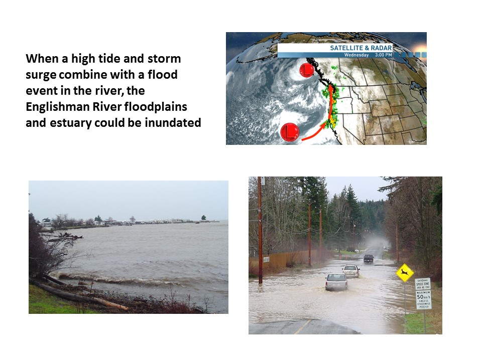
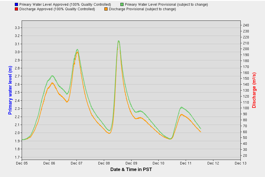
Picture
Picture
Time and Tide
Wait for No Man

​2016 Tide Guides
for this Area
​
Click the drip to link 

Click below to see Real-Time Hydrometric Data Graph for ENGLISHMAN RIVER NEAR PARKSVILLE 

Picture
Picture

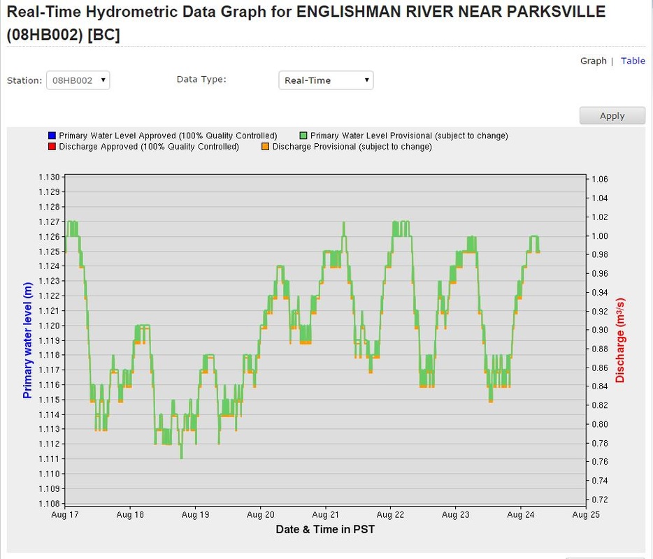
Our Oceanside Water: Opinion Blog.

Recent:
How to create a desert in 140 years.  
Picture

Troubled Water
More than ​42,000 Views 

This Video is more than 50 minutes long if you only wish to see the Oceanside segment, jump to minute 24 and watch the part from this area.
Water is largely taken for granted by consumers but it's becoming "blue gold" in the 21st century. Troubled Water examines the threats to public water systems and watersheds using the East Coast of Vancouver Island as a case study. 
Profiling a variety of water sources that represent typical water systems across North America, Troubled Water uncovers the common threats to these systems. The film highlights some good examples of watershed stewardship and encourages viewers to work toward maintaining water as a public trust in their own communities.
Picture
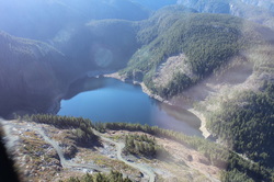
Photo credit Ken Neden
Arrowsmith Lake stores water for a growing population
                                      Click image to see more


This website is under development starting September 2015

Home

About

Blog

Contact

Written by Trevor Wicks