|
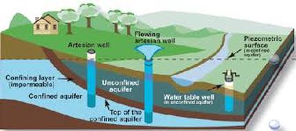
Groundwater (or ground water) is the water present beneath Earth's surface in soil pore spaces and in the fractures of rock formations. A unit of rock or an unconsolidated deposit is called an aquifer when it can yield a usable quantity of water. The groundwater in this area is under stress both for quantity and quality.
|
|
|
This Environment Canada website fills in a lot of gaps in basic groundwater information.
|
Groundwater in the Arrowsmith Oceanside Area
|

|
The area has highly complex geology, formed by tectonic forces, glaciations, sea level fluctuations etc. The resulting inconsistent land types cause considerable variation in groundwater levels and availability.
The video below demonstrates groundwater. |

Groundwater is mostly non-renewable, study finds Less than 6% of groundwater is replenished within 50 years. In this area the amount of precipitation that actually infiltrated into the groundwater each year is estimated at between 10 -18 cms near the coast to 18 - 25+ at higher elevations.
http://www.cbc.ca/news/technology/groundwater-study-1.3318137 Click the drip |
|
Understanding and Protecting the Well and Source.
Groundwater and well-head protection are essential components to providing healthy drinking water. Water can move through the ground at a few meters a year or many meters an hour.
Even if the well is tens or more than a hundred meters deep, contaminated surface water could reach the bottom of the well within a very short time during a heavy rain event.

Click the drip for more information
Ministry of Environment Water Protection & Sustainability Branch: Well Protection Toolkit
Ministry of Environment Water Protection & Sustainability Branch: Well Protection Toolkit
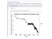
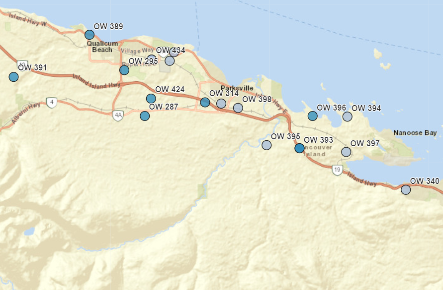
British Columbia Groundwater Observation Well Network
British Columbia Groundwater Observation Well Network can show the general groundwater trends in this area.
If you click the top line Select an observation well from the list
There are 20 relevant wells that are updated on a regular basis.
If you click the top line Select an observation well from the list
There are 20 relevant wells that are updated on a regular basis.

|
|
|
Well #287 COOMBS (BURGOYNE ROAD)
Well #303 QUALICUM BEACH (YAMBURY RD.) Well #304 PARKSVILLE (DESPARD RD) Well #310 BOWSER ( GAINSBURG RD.) Well #314 PARKSVILLE (SPRINGHILL RD.) Well #321 QUALICUM (LEEWARD WAY) Well #389 QUALICUM BEACH (W. ISLAND HWY) Well #391 LITTLE QUALICUM (MEADOWOOD WAY) Well #392 NANOOSE (DAWSON RD DEEP) Well #393 NANOOSE (DAWSON RD SHALLOW) Well #394 NANOOSE (NUTTAL DR.) Well #395 NANOOSE (RIVER'S EDGE DR. Well #396 NANOOSE (BALLENAS RD.) Well #397 NANOOSE (NORTHWEST BAY RD.) Well #398 PARKSVILLE (TRILL ROAD) Well #425 QUALICUM (SPIDER LAKE RD. DEEP) Well #426 QUALICUM (SPIDER LAKE RD. SHALLOW) Well #427 QUALICUM (COCHRANE RD. SHALLOW) Well #433 QUALICUM (GARDEN RD. E. DEEP) Well #434 QUALICUM (GARDEN RD. E. SHALLOW) |
|
|
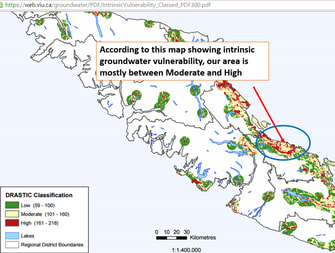
Vancouver Island Water Resource Vulnerability Mapping Project.
This in depth, well researched report provide a technical explanation on the likelihood of groundwater becoming contaminated. https://a100.gov.bc.ca/pub/acat/public/viewReport.do?reportId=19413 Most of this area's geology is described as sand and gravel mixes at lower elevations. Sedimentary rock transitions to volcanic rock at higher levels. The amount of precipitation that actually infiltrated into ground is estimated at between 10 -18 cms near the coast to 18 - 25+ at higher elevations. |